Site Specific Weather Information
MAVIS provides a range of information and products linked to individual sites.
This page covers the site specific weather information available in the side drawer for selected and pinned sites. This includes:
Other site related information is available and documented elsewhere in the guide. For other site related products, please see the further reading section at the end of this page.
TAFs
Terminal Aerodrome Forecasts (TAFs) provide a concise summary of the expected range of weather conditions at an aerodrome for a specified period. They include surface wind, visibility, weather phenomena, cloud, and relevant significant changes.
A TAF typically covers a geographical area of 5 nautical miles (around 8 to 9 kilometres) from the centre of the runway.
Issue times and validity
TAFs are issued every 3 or every 6 hours, depending on the validity period of each TAF. TAFs are issued approximately 1 hour prior to the start of their validity period. A TAF is only issued when regular, compliant METARs are being produced. Aerodromes that generate METARs normally also have TAFs.
Some locations do not issue a METAR at night. When this is the case, no TAFs are issued for the period when METARs are not being produced. The next TAF is issued shortly after the first METAR the next morning.
9 hour TAFs
The following times apply to TAFs with a 9 hour validity period, all times are in UTC:
| Start time | End time | Required time of issue |
|---|---|---|
| 00:00 | 09:00 | 23:00 |
| 03:00 | 12:00 | 02:00 |
| 06:00 | 15:00 | 05:00 |
| 09:00 | 18:00 | 08:00 |
| 12:00 | 21:00 | 11:00 |
| 15:00 | 00:00 | 14:00 |
| 18:00 | 03:00 | 17:00 |
| 21:00 | 06:00 | 20:00 |
24 and 30 hour TAFs
The following times apply to TAFs with a 24 or 30 hour validity period, all times are in UTC:
| Start time | End time | Required time of issue |
|---|---|---|
| 00:00 | 06:00 | 23:00 |
| 06:00 | 12:00 | 05:00 |
| 12:00 | 18:00 | 11:00 |
| 18:00 | 00:00 | 17:00 |
TAFs have a minimum validity period of 2 hours. Normally TAFs are valid for either 9, 24 or 30 hours. The validity period of TAFs is determined by the Civil Aviation Authority (CAA), taking account of the nature of air traffic operating to each airport.
METARs
Meteorological Aerodrome Reports (METARs) provide a concise snapshot of the wind, visibility, weather, cloud, temperature and pressure at an aerodrome at a particular time. During the operational hours of an aerodrome the METAR must be assessed by a qualified observer. A METAR only represents the weather conditions of a specific location at the time of issue. METARs are normally produced by a qualified observer. Many airports have now adopted automated systems to produce METARs.
Some UK aerodromes have CAA approval to issue auto-METAR outside of the operational hours of the aerodrome. However auto-METAR must be monitored by a qualified observer and amended should conditions not reflect the automated observations.
Issue times and validity
METARs are issued every 30 minutes in the UK at 20 and 50 minutes past the hour. Around 55 UK aerodromes produce METARs. The UK Aeronautical Information Publication (AIP), section GEN 3.5 (opens in a new tab), lists the airports that produce METARs. Special Meteorological Reports (SPECIs) are not issued in the UK (apart from at military aerodromes), though aerodromes provide local non-routine reports when significant changes to the weather occur between METARs.
METARs are only valid at the time they are produced and do not have a validity period. This means that when you read a METAR, you are reading the weather conditions at the time of issue, not the current weather conditions at the aerodrome.
Aerodrome Warnings
Aerodrome Weather Warnings are issued by the Met Office (opens in a new tab) according to a set of predetermined forecast conditions. These warnings are issued on behalf of the Civil Aviation Authority (CAA) and focus on local ground and near aerodrome safety. These warnings differ from en-route warnings such as SIGMETs.
They are as follows:
- Strong Wind:
- Issued when a strong wind with a mean speed of 20 knots, gusts of 28 knots, or both, are expected at the airfield.
- Gale:
- Issued when a strong wind with a mean speed of 34 knots, gusts of 43 knots, or both, are expected at the airfield.
- Frost:
- Issued when either:
- An air frost (air temperature of 0°C or lower) is expected at the airfield
- A ground frost (a surface temperature of 0°C or lower) is expected at the airfield.
- A ground and air frost (surface and air temperatures of 0°C or lower) is expected at the airfield.
- Issued when either:
- Snow:
- Issued in advance of a snow event.
- Fog:
- Issued when fog or freezing fog is expected to reduce visibility to less than 600m.
- Thunderstorms:
- Issued when a thunderstorm, is expected at or within 5 nautical miles of the airfield.
- Either hail, squall or both may be present.
- Hail:
- Issued when hail is expected at, or within 5 nautical miles of the airfield.
- Freezing Precipitation:
- Issued when freezing precipitation is expected to fall at the airfield.
- Temperature Inversion:
- Issued when a temperature inversion of 10ºC or more is expected to exist in the lowest 1000 FT.
Further detail about aerodrome warnings is available on the pilot resource portal (opens in a new tab).
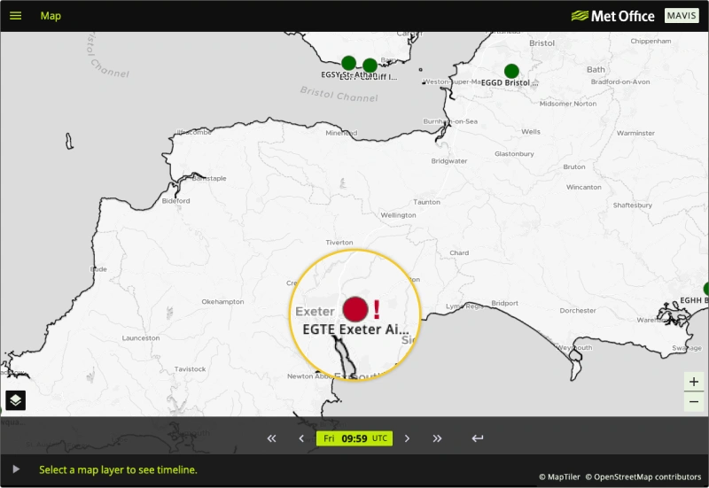
Aerodrome warnings are displayed on the base map of MAVIS, indicated by a red exclamation mark (!) next to the aerodrome affected. Clicking on the site icon will open the side panel to reveal the full details of the warning.
Example: